Baglyaskő

3
Baglyaskő
Baglyaskő
Baglyaskő

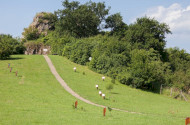
One of the best studiable diatremes in the territory of Novohrad-Nógrád Geopark is Baglyaskő. It may be 3.54 to 3.84 million years old.

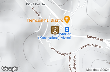
Its debris rampart, which was formed during the volcano's phreatomagmatic activity, has eroded and the breccia formed in the magma canal has got to the surface. The diatreme was broken through by a basalt vein, creating syngenetic caverns. One of them is a mud-bag, in whose walls a duct carrying hydrothermal solutions can be recognized (G60). Baglyas-kő is a small rock and it is only 70-90 m in diameter, rising as a cone at first and then with steep walls as high as 301 m out of its environment, the height of which ranges between 270-275 m. The eruption started with clast-scatter, and then the lava came up through a cylindrical chimney within the basalt tuff that had already consolidated, and formed a smaller cone. It is so much eroded, that only the stock of the crater has remained. The so-called “Karoly-shaft” which stretches underneath the Baglyas-kő revealed a basalt-peduncle breaking through coal beds, infilling of the former chimney, which turned coal into coke at the contact points. (JUGOVICS 1942) The cave can be found in the south side of the steep rock, at 285 m above sea level. What is called today as Baglyas-kői Basalt Hole, actually, is not a single hole, but a system formed by three holes right next to each other (obviously a genetic unit). The most striking thing is a lower horizontal corridor. It opens from a 3.5 m high and 2.5 m wide mouth, but after 2 m it shrinks into a 1-1.2 m high and 1.5 m wide corridor that can be passed only crouching down. It leads as far as 7.3 m with a further shrinking width and reducing height, to the direction of 355°. Its side-walls and vault consist of dark grey basalt at the entrance, and further inside, of scoria basalt; its floor is covered with a thin layer of clast. The inner and bigger part of the corridor looks artificial, but maybe it is just the former tight cave was enlarged. A shaft leading downwards form the passage at the mouth makes up the second part of the system. It has a long oval cross section with a long axis of 2.3 m and a small of 80 cm. The direction of the longer axis is the same as that of the corridor. The shaft is of 2 m deep at present, but there is some clast on its floor which seems to be thick, so its original depth must be a lot more than that. It walls are composed of dark grey compacted basalt. The third line of the system is situated 4 m higher and 2 m further east (to the right) than the bottom of the mouth. It is a “tube” with a 40 × 40 semicircular cross section, 2.40 m long and leading towards the north; it can be passed only crawling. It has scoria basalt walls and a clastic floor. This system of holes including the three branches described above, has a total length of 12.70 m. No special equipment is needed for exploring. Early scientists’ had different opinions on its formation. OZORAY (1957: 1960) describes it as a gaseous or phreatic explosion pipe, SZENTES (1971) says it is a tectonic cavity, BERTALAN (1958) considers, it is a cavity of tectonic origin, but later was modified by post-volcanic effects. Although not only the corridor and the shaft have the same the direction, but it is the same as that of the lava break-through and the fault on the top, but this formation cannot be considered as a result of real tectonism. The direction of 175° - 355° is marked by a compact dark grey basalt dike that subsequently forced open the reddish basalt which got solidified earlier with scoria, and here, on the surface of this border, a phenomenon similar to tectonic fault occurs. The shaft in cave was primarily formed by gaseous or phreatic explosion breaking out on the surface of this dike, and the horizontal corridors as well, the lower of which was also enlarged artificially. No real formations can be seen in the cave, apart from mineral crystals of the host rock and some inclusions that come from the base rock, and in the walls of the passage. These are half a cm big olivine and augite lumps, some sizeable pieces of oligoclase-feldspar and quartz and sandstone inclusions in the basalt. The cave is dry, dusty – and due to its southern aspect, it is warm fairly light. We could not discover any living creatures in it. From the footprints in front of and inside the cave, it may be deduced that many people, especially kids or teenagers visit the cave. (Its mouth faces a gipsy colony which is at the foot of the hill.) If the clast was removed from the cave, not only its size would increase, but it would supply some further information about its genetics.

RELATED

Salgótarján - Boszorkány-kő Geológiai Tanösvény (Kis-Salgó)

Salgótarján - Boszorkány-kő Geológiai Tanösvény (Kis-Salgó)

04/04/2018 11:18 AM
Baglyaskő
Salgó várától déli irányba haladva, néhány perces sétával érhetjük el Boszorkánykő (Kis-Salgó) szikláit. A Boszorkánykő körül kialakított geológiai tanösvény egy kisebb hasadékvulkán igen változatos kőzeteit mutatja be. Láthatunk itt mélyből felszakított üledékzárványokat, hajlott lávalemezeket, kukoricacsövesedő bazaltoszlopokat, ami a bazalt egy jellegzetes mállási formája.A sziklagerinc K-i fala közel függőleges, ez az egykori törésvonal természetes úton kibontódott fala, ami elérheti a 15-20 m magasságot is.A néveredethez kapcsolódó monda szerint itt szabadultak meg a boszorkánysággal megbélyegzett asszonyoktól.Salgótarjántól északra, a Salgóbánya település feletti 625 m magas sziklacsúcson emelkednek a város egyetlen középkori műemlékének, Salgó várának romjai. A várrom és környéke természetvédelmi terület.A XIII. században épült várról elősször egy 1341-ben kelt oklevélben Castrum Salgov néven tesznek említést.Története során többször cserélt gazdát, 1554-től kezdődően 39 évig birtokolta a török, majd 1593-ban sikerült visszafoglalni.Irodalmi vonatkozású érdekessége, hogy a romokat 1845. június 11-én Petőfi Sándor is felkereste. Látogatásának állít emléket 1923 óta a hajdani várkapu melletti sziklás bazaltoszlopokon lévő fehér márványtábla. A vár falainál ülve született a költő Salgó című verse.A várromról körpanoráma nyílik a Bükk, a Mátra, a Cserhát és a Börzsöny vonulataira, de kedvező időjárás esetén a Magas-Tátra csipkés gerince is látható. A várrom szabadon látogatható. (turautak.com)
Read more
2023/1 2. The first few days

2023/1 2. The first few days

04/19/2023 2:37 PM
Am 14. Maerz stieg ich ins Flugzeug in Richtung Budapest. Natürlich war ich ziemlich aufgeregt und gespannt. Ich war vorher noch nie in Ungarn. Wie werden die Leute dort sein und wie wird meine neue Heimatstadt aussehen? Was wird mich im Bükk-Region Geopark erwarten? Fragen über Fragen… Glücklicherweise wurde ich von Balázs am Flughafen abgeholt und meine Aufregung legte sich etwas nach dem herzlichen Empfang. Auf dem Weg in die Wohnung machten wir sogar noch einen Zwischenstopp bei Aldi, da am 15. Maerz ein Feiertag in Ungarn ist (Gedenktag der Revolution von 1848) und die Geschaefte geschlossen hatten. Ich nutzte den freien Tag direkt, um etwas die Innenstadt zu erkunden. Dort habe ich den Dobó-István-Platz, das Rathaus, sowie die Basilika gesehen. Erster Eindruck? Hier laessts sich aushalten! Am Samstag hat mich Balázs und sein Vater auf eine Wanderung im nahegelegenen Aggtelek Nationalpark eingeladen. Wir marschierten im Wald 15 km entlang der slowakischen Grenze von Aggtelek in Richtung Gömörszőlős. Kurz vor unserem Ziel wurden wir noch mit einem schönen weitlaeufigen Ausblick belohnt. Dort konnten wir bis zum Mátra-Gebirge sehen! In Gömörszőlős, wo es unter Anderem ein ökologisches Ausbildungszentrum gibt, haben wir dann zusammen noch zu Abend gegessen (Ungarische Gulaschsuppe) und den Abend mit einem Kartenspiel ausklingen lassen (auf ungarisch gar nicht so einfach ;) ) Es war ein sehr schöner Tag, vor allem, da ich von allen Teilnehmern herzlich empfangen und direkt in die Gemeinschaft aufgenommen wurde. Am Sonntag stand dann die Besichtung der Burg von Eger an. Von dort hat man einen guten Ausblick über die Stadt. Im Keller der Burg befindet sich eine Ausstellung zu einer der grössten Waffensammlung in Ungarn und es kann das ehemalige Verlies besichtigt werden. Für Geschichtsinteressierte sehr interessant!
Read more
2023/1 1. Sziasztok!

2023/1 1. Sziasztok!

04/19/2023 2:34 PM
Hallo zusammen! Mein Name ist Hanna und ich bin die neue Freiwillige der Organisation kulturweit aus Deutschland. Ich werde bis Ende August dieses Jahres in Eger bleiben. Hier sind ein paar Fakten über mich: Aufgewachsen bin ich in einem kleinen Dorf namens Trautmannshofen in Bayern, das in der Nähe der Stadt Neumarkt in der Oberpfalz liegt. Die nächstgrößere Stadt ist Nürnberg (Vielleicht habt ihr schon mal davon gehört.) Im Februar bin ich 23 Jahre alt geworden. Zusammen mit meinen Eltern wohne ich noch in Trautmannshofen. Mein älterer Bruder Lukas wohnt in Neumarkt. In meiner Freizeit bin ich gerne draußen, gehe wandern oder fahre mit dem Fahrrad. Außerdem lese ich gerne spannende Romane oder Krimis und gehe an den Wochenenden mit Freunden aus. Nachdem ich 2016 meinen Realschulabschluss gemacht habe, habe ich eine Ausbildung zur Industriekauffrau bei der örtlichen Öko-Brauerei "Neumarkter Lammsbrau" gemacht. Seit 2019 war ich bei der Thule GmbH in Neumarkt im technischen Kundendienst tätig. Nun war es Zeit für ein neues Abenteuer! Da ich schon immer mal für eine gewisse Zeit im Ausland arbeiten wollte, nutzte ich die Gelegenheit und bewarb mich für den Naturfreiwilligendienst bei kulturweit. Glücklicherweise wurde ich angenommen und mir wurde angeboten, den Freiwilligendienst im Bükk-Region Geopark in Eger, Ungarn zu absolvieren. Ich habe das Angebot angenommen und bin nun glücklich und neugierig, welche Erfahrungen dieser neue Lebensabschnitt für mich bringen wird!
Read more