Geodivesity Day at a transnational geopark 09/13/2024 8:17 AM

Geodivesity Day at a transnational geopark

1
Geodivesity Day at a transnational geopark

October 6 is the International Geodiversity Day, celebrated worldwide by UNESCO. In order to Conserve the Past and Sustain the Future, the rich repository of the geological heritage of the transnational, Slovak-Hungarian Novohrad-Nógrád UNESCO Global Geopark will also join the event. On the traditional geotope days, October 5th and 12th, from the state border area to Ipolytarnóc and from Sámsonháza to Szentkút, it organizes many exciting and unconventional geotours into the world of volcanoes of the past.

In the Miocene Park of the Ipolytarnóc Fossils geosite, a thematic tour will be organized on October 5, the details of which, along with the background of the geodiversity day, can be found at this link.

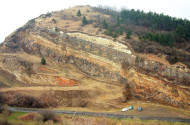
Also on October 5, at 10:30 a.m., a special 10 km long tour to the basalt region of the Medves Plateau will start from the Eresztvény Visitor Center of the geopark, during which the participants will learn about the geohistory and mining of the picturesque landscape, while visiting several reclaimed quarries. You can participate in the tour free of charge, pre-registration can be done by sending a message to the email address info@nngeopark.eu or by calling the landline +36 32 423 303.

And on October 12, the chief geologist of the geopark, Péter Prakfalvi, will lead an interesting tour in the Cserhát mountain, which starts at 8:30 a.m. from the Municipal Hall of Nagybárkány. The tours goes to the startovolcano of Samsonhaza and ends at the pilgrimage site of Szentkút. The exact details of the 12.4 km long tour are described on the Kéktúra website.

RELATED

2022/1. - 9. Tree studies

2022/1. - 9. Tree studies

08/23/2022 3:57 PM
Baumstudie[28.07.2022]Gemeinsam mit einer ungarischen Studentin haben wir in der letzten Zeit begonnen Bäume auf einer Weide zu tracken und nach einem ausführlichen Katalog zu beurteilen. Im Nationalpark sprechen wir immer von „Veteran Trees“, also besonders alten Bäumen. Bisher kann keiner Abschätzen wie viele es sind, es sind nur recht grobe Angaben von ca. 1000 Bäumen. Jedem Baum ist ein A4 Zettel gewidmet, auf dem erst Daten wie die Koordinaten, der lateinische Name und Maße wie z.B. die Höhe und der Umfang angegeben werden müssen. Für die Ermittlung der Höhe des Baumes wird eine Entfernung von 20m abgemessen. Von dort aus wird mit einem analogen Höhenmesser der Winkel zum Beginn des Stamms und der Winkel zum höchsten Teil der Baumkrone bestimmt. Die beiden Zahlen ergeben gemeinsam die Höhe. Danach kommen 36 Felder in denen unter anderem Angaben über Astlöcher, Kronen- oder Starkastabbrüche, Krankheits- oder Pilzbefall, Moos- und Flechtenvorkommen und Nester, die sich im Baum befinden. Zusätzlich kommen dann noch einmal 15 weitere Felder, wo z.B. nach anderen Bäumen in der direkten Umgebung gefragt wird. Die Aussagen, die wir über die Bäume treffen werden immer mit der Hilfe von für solche Studien angefertigte Kataloge getroffen. So sind in manchen Fällen verschiedene Bilder dargestellt und wir müssen entscheiden, welches dem untersuchten Baum am nächsten kommt. Zusammengefasst ist es eine sehr detaillierte Studie, weshalb wir am ersten Tag auch nur insgesamt 8 Bäume geschafft haben. Mit der Zeit wird man jedoch deutlich routinierter und muss nicht mehr alles erst im Katalog nachschlagen, wodurch die Arbeit deutlich schneller vorangeht. Insgesamt haben wir dennoch nur 60 von den ca. 1000 Bäumen tracken und beurteilen können.
Read more